


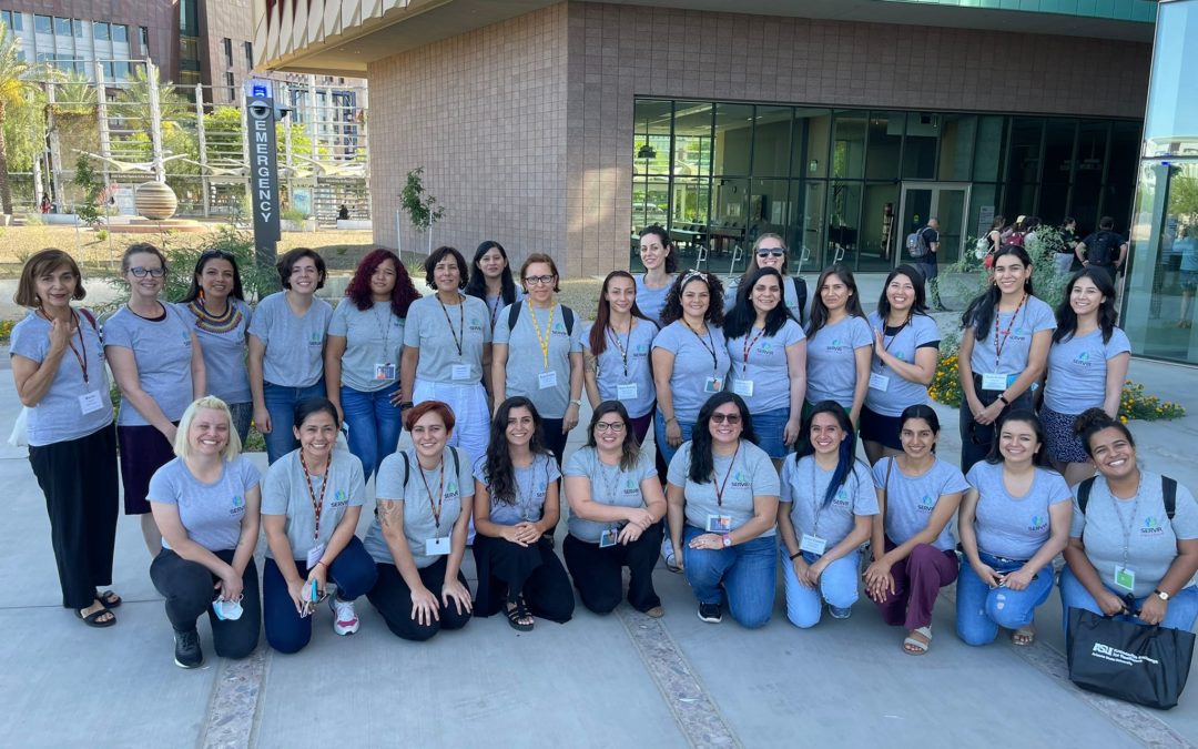
From May 15 to 20, 22 professional women from South America shared an intense face-to-face workshop, organized by the Knowledge Exchange for Resilience Program of Arizona State University (ASU) and the SERVIR-Amazonia Program, entitled “Advancing Women’s Prosperity in the Workplace”. The objective of the event was to help a group of early-career women in geospatial sciences and services to strengthen their capacities and become multiplier agents that apply what they have learned in their own projects. This is done through a Train the Trainers methodology.
It is well known that in Latin America, as in other regions, the gender gap persists in terms of women’s access to technology, being more pronounced in the use of Geographic Information Systems (GIS). Their participation in leadership positions in public and private entities is also limited. For this reason, the SERVIR-Amazonia Program promotes the strengthening of women’s technical and social skills in environmental sciences and geospatial technologies, generating processes aimed at sharing experiences and practical ideas, and the generation of professional networks.
In this sense, efforts were combined to carry out this activity with ASU and the Knowledge Exchange for Resilience Program, together with SERVIR Global. Thus, SERVIR-Amazonia selected 22 participants from five countries, who are articulated with public and private institutions that are part of SERVIR-Amazonia partners. These institutions were:
* Brazil: CEMADEN, EMBRAPA, IMAFLORA, SEMAPI-ACRE, SEMAS-Para.
* Colombia: Alliance Bioversity International & CIAT, IDEAM
* Ecuador: EcoCiencia, GAD Imbabura, INAMHI, CIIFEN
* Peru: ACCA, IAAP, MINAM – DGOT, MIDAGRI – SERFOR, SENAMHI, Universidad Científica del Sur
* Guyana: Institute of Gender Studies-University of Guyana-NAREI
For the organization of the event, led by Patricia Solis, Executive Director of The Knowledge Exchange for Resilience Program, a powerful team of co-organizers from ASU, NASA, USAID, and SERVIR-Amazonia was convened, who drove the process[1] and who accompanied the entire workshop in person, also counting with distinguished guests from other entities.
The training was organized in six blocks:
* Mentoring and networking.
* General knowledge of gender and environment.
Promotion of skills for empowerment (Power Skills):
* Technology Skills.
* Technological Skills.
* Personalized counseling.
* Preparation and final presentation of participants’ proposals.
In this way, new technical knowledge was promoted, reinforcing others, and introducing skills and abilities. The technical training included reviewing and exercising in geospatial programs and services such as GEDI, Global Ecosystem Dynamics Investigation, which uses Lidar to map forests, Google Earth Engine, and Climate. Although it was also an axis of work to analyze and discuss the interrelationships between gender issues and geospatial services, how to design and work around the personal vision; how to strengthen negotiation skills and interdisciplinary collaboration, networking, mentorship, and cultural intelligence, as well as the importance of considering the projection of geospatial services (GIS) to communities.
Marina Irigoyen, Gender Advisor at SERVIR-Amazonia, together with Emily Adams (NASA SERVIR Eastern and Southern Africa Science Coordinator), presented the methodological proposal of Gender Analysis around GIS, as well as the experience of gender analysis around RAMI, a geospatial service oriented to the detection of illegal mining in Madre de Dios, Peru.
The professionalism of the ASU team, as well as the pleasant facilities of the university’s headquarters, with an excellent infrastructure that emphasizes the use of renewable energies, should be highlighted. A series of extra-curricular activities completed the program, which promoted exchange and networking among the participants.
As a result of the day, the participants designed their proposals for continuity in order to replicate what they learned with other women in their workplaces or communities. There are 16 proposals – several of them joint initiatives of the participants – that combine face-to-face and virtual activities.
Among the proposals referenced is training for the introduction and use of various geospatial tools such as Google Earth Engine or Tethys Plattform; the dissemination of applications for monitoring forests or land use, incorporating women; collaborative mapping to detect disaster areas, among others. But also some related to the development of the network of contacts and capacities for negotiation and mentoring. This collaborative design is quite a challenge!
From SERVIR-Amazonia we reaffirm our commitment to follow up on the initiatives of the participants, supporting them with methodologies and tools, considering the expertise of our team and partners.
[1] The organizing committee, in addition to Patricia Solis, includes: Emily Adams (NASA SERVIR Eastern and Southern Africa Science Coordinator); Natalia da Silveira Arruda (Ph. D. at ASU); Erin Carr-Jordan (Managing Director of the Digital Equity Institute ASU); Amy Frazier (Associate Professor in the School of Geographic Sciences and Urban Planning at ASU); Georgia Hartman (Gender and Environment Advisor at the Center for Gender Equality and Women’s Empowerment at USAID); Marina Irigoyen (Gender Advisor at SERVIR-Amazon); Vanesa Martin (Regional Science Associate at SERVIR-Amazon Center); Helen Parache (Regional Science Coordinator at SERVIR-Amazon).