

When Stephanie Spera talks about her work with the Applied Science Team that she is leading on “Quantifying the Effects of Forest Changes on Provisioning and Regulating Ecosystem Services” in the Southwestern Amazon, she mentions two motivations. The first, biophysical, is to contribute to prevent the Amazon from reaching a tipping point, meaning possible irreversible damage to the world largest river basin that comprises nearly half of tropical forest carbon stocks. The second motivation relates to the 33 million people, including 1.5 million indigenous people from 358 different groups whose livelihoods depend on the ecosystem services that they receive from the Amazon basin.
Illustration on the right: The ideal distribution of ecosystem services From Ruth de Fries et al. 2004, Foley et al 2007

Stephanie and her team follow their motivation by pursuing two interconnected streams of work. On the one hand they intend to better understand the effects of land use and land cover change driven by road construction and connectivity in this transboundary region. On the other hand they create maps and products that highlight potential impacted areas which they then deliver to local communities.
“The Applied Science Program of NASA and SERVIR-Amazonia is the perfect opportunity to work at the intersection of science, technology and innovation, allowing us to translate data into useful tools for development”, says Stephanie. “We want to allow regional and local planners and decision-makers, and the citizens of Acre and Ucayali, including the Indigenous and traditional communities of the Sierra del Divisor, Yurua, and Purus watersheds to better understand the tradeoffs between development activities and ecosystem services.”
Negative effects of forest clearing
Recently, Hollywood actor and environmental activist Leonardo DiCaprio added his voice to others warning about the damage of illegal road building in Ucayali and calling for action (see Instagram post below).

Indeed, in Spera’s transboundary area of study between Brazil (Acre) and Peru (Ucayali), local and regional forest clearing and degradation are affecting the hydrologic provisioning and regulating of ecosystems services. Additional forest clearing and degradation would be the result of a planned transboundary transportation corridor between Pucallpa, Ucayali and Cruzeiro do Sul, Acre. Other planned road construction might also affect the hydrological ecosystem services with cascading effects on natural resources, disaster resilience, conservation areas, biodiversity, and indigenous communities in the region. Deforestation and forest degradation have been linked to myriad negative environmental consequences, such as decreases in biodiversity, evapotranspiration rates, and carbon storage, and increases in temperature, dry season length, streamflow, fire occurrence, and CO2 emissions.
What the algorithms say
Yunuen Reygadas is a postdoctoral fellow with a PhD in Geography at the University of Richmond and part of the applied science team. A recent open access publication that she co-authored with Spera, Salisbury and SERVIR team members, highlights land-cover change dynamics that have occurred in this remote, transboundary region over the last two decades. They also summarize tradeoffs between open-source, Landsat-based forest disturbance mapping algorithms to allow stakeholders to better understand which algorithm might best suit the user´s study area and research objective.
Using Google Earth Engine, the team compared the performance of three algorithms –Continuous Degradation Detection (CODED), Landsat-based detection of trends in disturbance and recovery (LandTrendr), and Multi-variate Time-series Disturbance Detection (MTDD)– to detect and characterize forest disturbances during the 2000–2020 period. In general, the results of all of the algorithms agreed with the reference data: overall accuracies were 94% (± 0.6% LandTrendr), 95% (±0.6% MTDD), and 96% (± 0.6% CODED). Although the map products exhibit similar spatial patterns, they often differ on the specific disturbance extent. CODED works well in capturing disturbances associated with roads, MTDD excels best at capturing entire disturbance patches, and LandTrendr excels both in terms of user friendliness and range of output options. They conclude that it would be incorrect to assume that any one algorithm is the most accurate; instead, they describe the strengths and weaknesses of each algorithm to offer users insights about which algorithm might best perform in specific scenarios.
A complementary analysis by other members of Spera’s research group, including research assistant Scott LaRocca, on weather station data across Ucayali and Acre show that maximum temperatures are increasing. The team is now working to understand how these mapped forest disturbances are contributing to changes in ecosystem services, like precipitation, evapotranspiration, and land surface temperature. Preliminary results show that there is a general annual decrease in evapotranspiration rates from forest disturbances (especially from deforestation) over the study period. For example, during 2003, deforested areas transpired about 6% less than intact forest; by 2020, that difference increased to 16%. Forest disturbances in Acre and Ucayali between 2003 and 2020 accounted for a loss of 37 km3 of water.
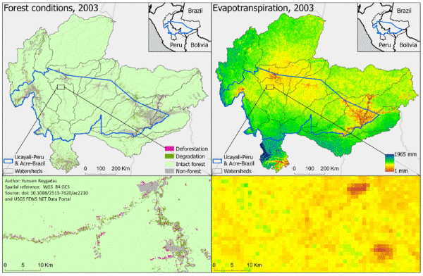
Forest conditions (Reygadas et al., 2021) vs Evapotranspiration (https://earlywarning.usgs.gov/fews/product/460) in the Southwestern Amazon between 2003 and 2020.
Giving back better
Stephanie’s team is determined to engage with different user groups and reach a broad audience with its research.
First, there are the indigenous communities who live in the transboundary area. Co-investigator David Salisbury, an associate professor of Geography and the Environment at the University of Richmond, has been collaborating with local partners and indigenous people organizations for more than a decade. Through workshops and meetings, he has documented with them the changes in their livelihoods: Less predictable precipitation and streamflow, drier soils, warmer air temperatures, and a less humid forest. In November, David Salisbury met with local stakeholders to deliver analysis in paper map and poster format to governmental offices, Indigenous organizations, and Indigenous communities in Ucayali and Acre. Indigenous communities and their organizations are concerned how roadbuilding will affect their communities, forests, and ecosystem services, and use those maps to discuss the challenges, impacts, and possible solutions. Read more about communities perspectives on road building projects (in Spanish). Over the course of his visit Salisbury distributed 40 posters and 76 maps and discussed them with two Ucayali Government Offices, three Indigenous associations, three Indigenous communities, a university, an International Indigenous Congress, and a national park headquarters.
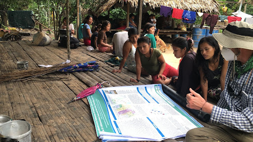
Indigenous women and David Salisbury use an ABSAT NASA SERVIR poster to discuss the importance of women’s leadership on health, education, and environment in the context of a road threatening their Indigenous community, November 2021.
Increasing the GIS capacity of national actors has been the focus of Yunuen who in 2021 led two 2-day training sessions in Spanish on how to use Google Earth Engine (GEE) to map forest degradation with landsat based algorithms. The team wrote all the code in GEE with the intention to share it with stakeholders. Participants came from SERVIR-Amazonia Hub partner organizations in Colombia, Peru, Brazil and Ecuador.
The team also holds monthly meetings with a large and diverse group of interested parties who discuss the latest progress of the project implementation, to respond to these stakholder’s interests, and to increase capacity of their partner organizations.
Lastly, this AST project provides myriad opportunities for students at the University of Richmond, where there are currently nine undergraduates engaged with this research. For example, two of the team’s outstanding students, Tereza Hernandez and Lindsey Barnard, performed an analysis on the rhetoric of Facebook and Twitter posts associated with roadbuilding in Peru and Brazil, and found that supporters of road building in the Amazon borderlands actually don’t usually live in the construction areas. They will present this work at the COnference of Latin American Geographers in January. Stephanie alsorecently won the H. Hiter Harris III Award for Excellence in Instructional Technology from the Virginia Foundation for Independent Colleges. She is constantly experimenting with new approaches to improve students’ learning, as evidenced by the launch of her recent podcast series “How we got Here” which she co-hosts with her colleague Dr. Rachel Lupien. The podcast, aimed at high-school, college, and graduate students, focuses on conversation with people who have figured out how to use their talents to combat climate change to inspire others to do the same.
Next steps
For its last year of implementation, the team will both maintain their website, where they publish their map and analysis in English, Spanish, and Portuguese and refine its ecosystem service analysis of disturbed areas. They plan to create an open-access geodashboard that will provide users with all of the data collated and generated over the span of this project, and allow users to visualize tradeoffs between forest disturbances and environmental variables such as temperature, precipitation, and evapotranspiration.
Finally, COVID permitting, the project will culminate with an indigenous stakeholder workshop where team members will gather, discuss findings, and build capacity.
See Stephanie Spera’s presentation at the NASA Applied Science week, August 2021
Authors of this blog