


SERVIR-Amazonia, an initiative of USAID and NASA, shares the Amazonian population’s concerns in regards to the impacts of fires currently affecting the Region, and renews its commitment to collaborate with populations, governments, research institutions, international community and other stakeholders to monitor and understand the causes and impacts of the fires affecting the Amazonian regions of Brazil and Bolivia.
One of SERVIR-Amazonia’s four service areas focuses on Fires and Droughts. The Program is working to emphasize the development and implementation of services that support the decision making process aimed at preventing fires and reducing their impacts. The team brings experience in climate science and fire remote sensing detection, risk mapping, impact on ecosystem services and prevention planning.
With that in mind, SERVIR-Amazonia consortium partners, which include the International Center for Tropical Agriculture (CIAT), Conservación Amazonica (ACCA), IMAFLORA and Spatial Informatics Group (SIG) along with experts from NASA and the University of Arkansas, would like to share that:
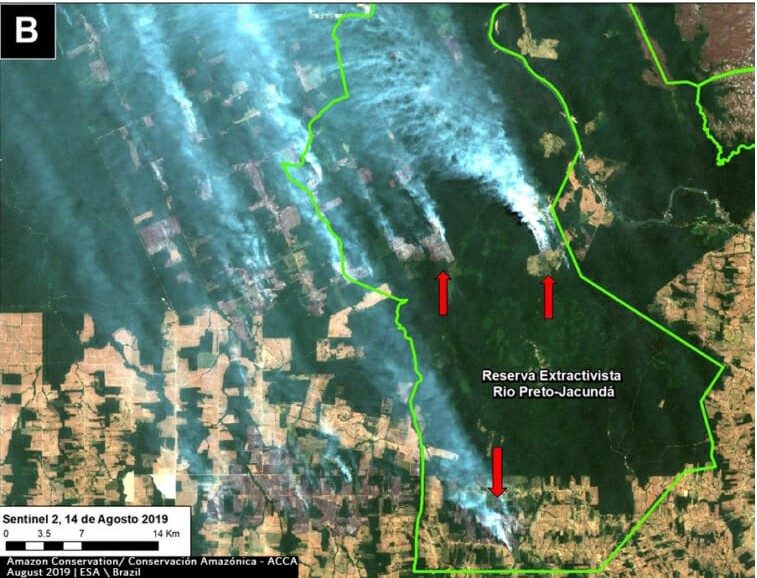
- The majority of the fires and hot spots seen from space in the Brazilian Amazon are associated with land cover types other than standing forests.
- Previous to the fires, preliminary data in the Brazilian Amazon point to an increase in deforestation of nearly 25% compared to the same period in 2018 according to the Brazilian National Institute for Space Research (INPE).
- There is potential for fires to escape to forested areas including indigenous territories and protected areas.
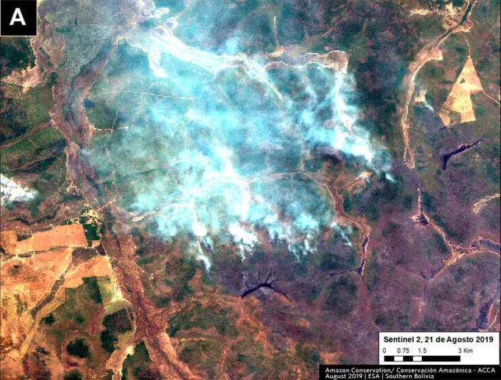
- The most intense fires are occurring in the southwestern Amazon, along the border of Bolivia and Peru, in areas characterized by a mosaic of forest and other land covers.
- Unlike other years of increased fire activity (e.g. 2005, 2010 and 2016) when fires were more clearly related to a well established drought, the preceding May-July 2019 period was not anomalously dry.
- July to September is the peak of the dry season in the southwestern Amazon. It is critical that efforts to monitor and prevent fires continue due to the expected persistence of dry conditions and enhanced potential for fires to spread to forested areas.
Hence it is important to:
- Monitor fires, including those in the forest understory and those at forest edges.
- Assess the area affected by fires and identify possible losses of primary forest, especially in indigenous lands and protected area.
- Monitor air quality and particulate matter. The recent fires and associated smoke have the potential to impact the regional population’s health.
Additional contribution from our Hub partners
Conservacion Amazonica (ACCA), through the Monitoring of the Andean Amazon Project (MAAP) has been monitoring deforestation since 2015, and has had replied to numerous requests to provide information regarding the current fires in the Amazon, including:
- MAAP #109: FIRES AND DEFORESTATION IN THE BRAZILIAN AMAZON, 2019
- MAAP #107: SEEING THE AMAZON FIRES WITH SATELLITES
- MAAP #108: UNDERSTANDING THE AMAZON FIRES WITH SATELLITES, PART 2
- PREVENIR ES CONSERVAR: PREGUNTAS Y RESPUESTAS SOBRE LOS INCENDIOS QUE VIENEN OCURRIENDO EN LA AMAZONÍA
The International Center for Tropical Agriculture (CIAT) will participate in a field mission in Bolivia with the goal of evaluating the impact of the fires in livestock farms near the town of Roboré. The visit also aims to identify which strategies, recommendations and action plans might minimize the impact of fires in these communities.
SERVIR-Amazonia Program experts will participate in a panel organized by the Universidad Nacional Agraria La Molina in Lima on September 12, to discuss the use of GIS tools for fire monitoring as well as the implication of fires in the Amazon Region for indigeneous communities.