


SERVIR-Amazonia partner ACCA releases the 100th MAAP report, presenting its first large-scale western Amazon analysis: Colombia, Peru, Ecuador, Bolivia, and western Brazil. MAAP is a project of Amazon Conservation and Conservación Amazónica-ACCA whose joint mission is to unite science, innovation, and community to protect the western Amazon – the greatest wild forest on Earth.
About the report:
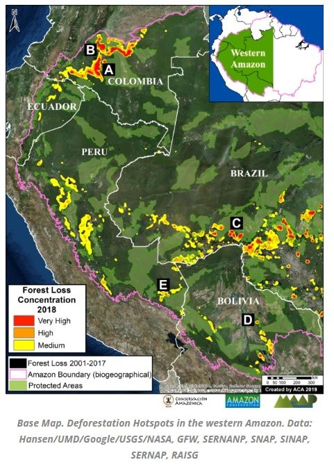
We use the new 2018 data* to identify the major deforestation hotspots across this vast and megadiverse landscape.
These data indicate 2.5 million acres of forest cover loss in the western Amazon in 2018, of which 1.9 million were primary forest.** In other words, the western Amazon lost 3.5 acres of primary forest per minute, with the vast majority in Brazil, Colombia, and Peru.
The largest concentration of forest loss was in the northeast Colombian Amazon (494,000 acres), including within national parks such as Chiribiquete and Tinigua.
We show satellite images of this area and other hotspots identified in Brazil, Bolivia (Mennonite settlement), and Peru (gold mining). In the case of Peru, we highlight that the government is now taking aggressive action to address this deforestation hotspot.
*2018 forest cover loss data, generated by the University of Maryland and presented by Global Forest Watch.
**For Spanish version, with data in hectares, please click Here
See more and download full report Here
Citation: Finer M, Mamani N (2019) Western Amazon – Deforestation Hotspots 2018 (a regional perspective). MAAP: 100.