


Ecuador has been engaging in national efforts to reduce carbon emissions from the forest sector, as an integral part of the National Action Plan for REDD+. Hence, the Ministry of Environment and Water of Ecuador (MAAE, for their initials in Spanish) and the Sub-Secretary of Natural Heritage has been implementing the National System for Forest Monitoring, with the objective of providing continuous and rigorous information about the forest and other ecosystems’ status and changes.
In collaboration with FAO and international donor agencies, such as the KfW development bank and Norwegian Agency for Development Cooperation (NORAD), Ecuador is building its National Forest Monitoring System. SERVIR-Amazonia, a joint partnership between USAID and NASA, is now contributing to Ecuador’s efforts to effectively reduce carbon emissions by implementing methodologies that reduce uncertainties in area estimations and applying state-of-the-art methods.
Improving accuracy assessment of land cover changes, implementation of time series analysis, and using Synthetic aperture radar (SAR) data are among some of the current needs highlighted by Ecuadorian authorities to improve their current system. SERVIR-Amazonia is supporting these requests by strengthening the capacity of technical staff from the Ministry of Environment and Water of Ecuador (MAAE) in sample-based area estimation and accuracy assessment. A workshop to provide customized assistance on area estimation using a sample-based approach was carried out in May together with FAO. A technical approach will be used to address sample design and area estimation; classification rules and labeling conventions; and quality management in data collection. The participants will be exposed to Standard Operation Procedures and examples of good practices for these key topics. In addition, examples of how to use SAR data and time series analysis will be presented.
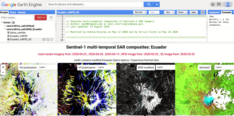
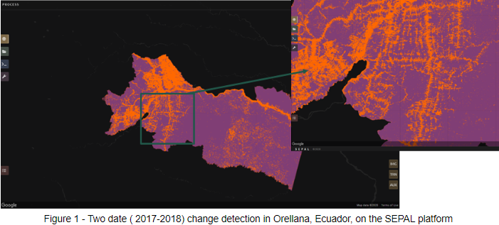
During the workshop, free and open-source Open Foris platforms, including SEPAL and Collect Earth Online (CEO) were presented to participants. SEPAL (see Figure 1) is an FAO open-source cloud computing environment for land cover monitoring that Ecuador has been using to generate their activity data, and Collect Earth Online is a SERVIR data collection platform used to view high-resolution imagery to collect reference data. A simple version of CEO, called Mapcha, was initially developed by the SERVIR-Mekong team in 2015, to respond to needs in the SERVIR-Mekong program for a cloud-based, open source software for visual interpretation of satellite imagery. Since its inception new functionality has been incrementally added based on user feedback through a collaborative partnership between SERVIR and FAO, with support from US Forest Service International Programs and SilvaCarbon. It was integrated with FAO’s Open Foris Initiative and renamed as Collect Earth Online in 2017. Building on this partnership, our SERVIR teams have also been collaborating with FAO to integrate tools built for MAE in Google Earth Engine for monitoring land cover, near real time fire detection, and landcover change detection into the SEPAL platform. Both platforms, co-developed by SERVIR and FAO, are linked into one seamless workflow, including an interface within SEPAL where users can access the CEO platform. During the event, we assessed a newly integrated forest dynamic monitoring component through visual interpretation of time series images, using both SAR and optical datasets. We also tested a sampling strategy from a recent paper from Olofsson and Lindquist (2020)* aimed at mitigating the effects of omission errors on area and area change estimates.
MAE is currently working to produce its carbon emission estimates for the 2018-2019 period to access their results-based payment for reduced deforestation for the third time, and working to improve their current methods for mitigating omission errors in their forest maps. This ongoing collaboration with SERVIR-Amazonia and FAO will contribute to MAE´s goals to effectively estimate emissions reduction and enroll in results-based payments in order for communities’ to sustain their conservation efforts.
* Olofsson, Pontus, Paulo Arévalo, Andres B. Espejo, Carly Green, Erik Lindquist, Ronald E. McRoberts, and María J. Sanz. “Mitigating the effects of omission errors on area and area change estimates.” Remote Sensing of Environment 236 (2020): 111492.
Authors of the Blog
- Karis Tenneson, Ecosystem Management Thematic Lead with SERVIR Amazonia, Spatial Informatics Group (SIG)
- Africa Flores, SERVIR-Amazonia Regional Science Coordination Lead and Land Use & Land Use Change Thematic Service Area Lead (NASA)
- Erik Lindquist, Forestry Officer, United Nations Food and Agriculture Organization
- Paula Paz, Research fellow, SERVIR-Amazonia, Alliance of Bioversity International and CIAT
- Ximena Herrera, Specialist Technician in Forest Monitoring and Forest Inventories, Ministry of Environment and Water of Ecuador (MAAE)
- Danilo Granja, Specialist Technician in Forest Monitoring and Forest Traceability, Ministry of Environment and Water of Ecuador (MAAE)
- Milagros Becerra, Research Fellow, Conservación Amazónica (ACCA)