


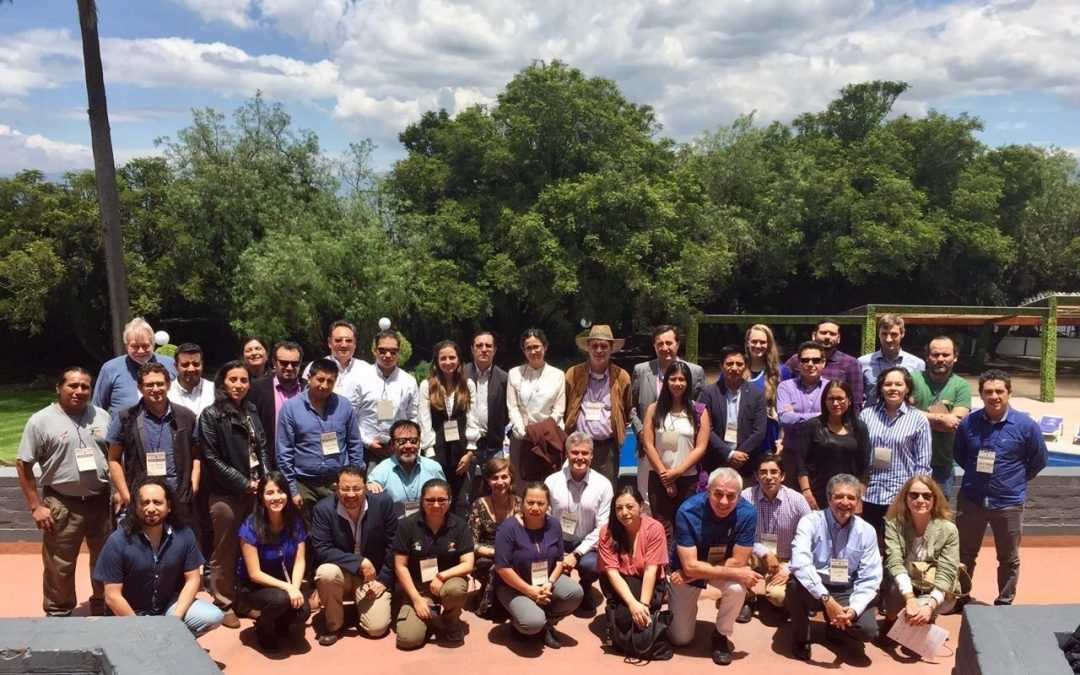
Citizen participation, a priority for attendants to the workshop
On 9 and 10 March 2020, the “Consultation about the Needs of the SERVIR-Amazonia Program Users” workshop was held in Quito, Ecuador, with the participation of 46 representatives of 31 governmental and non-governmental organizations, as well as civil society.
The workshop’s main goal was obtaining a preliminary approach, from the perspective of stakeholders, on the main problems/threats facing the Amazon region outlined in the four thematic areas covered by SERVIR-Amazonia, a program led by the Alliance of Bioversity International and the International Center for Tropical Agriculture (CIAT), funded by USAID and NASA. Based on this information, in a one-and-a-half-day participatory process, we identified information needs and opportunities to co-develop “services” in the form of applications, virtual geospatial information platforms and/or trainings to improve environmental decision-making in the Amazon.
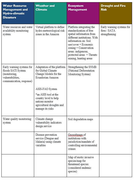
The 13 ideas of information services based on geospatial data
Participants developed 13 ideas of geospatial services in the four service-development thematic areas of the Program: Water Resource Management and Hydro-climatic Disasters; Weather and Climate; Ecosystem Management; and Drought and Fire Risk.
Stakeholder mapping
During the workshop, an initial discussion was carried out on the perception of participants about the current status of environmental decision-making based on geospatial information in Ecuador. Existing key stakeholders and services were mapped in a participatory fashion, according to the thematic areas. “This exercise showed that there is much information, stakeholders, and services already available”, commented one participant, adding that “Stakeholder mapping was important to strengthen actions already in force in the field and to strengthen partnerships”. For the Director of SERVIR-Amazonia, Carlos Gasco, this mapping is the main input to prioritize the services to be developed during the Program and it will be used in the stage of designing and co-developing services.
Achieve citizen engagement
A key discussion revolved around the dissemination mechanisms and citizen engagement, which have been found deficient, since information often remains with technicians and institutions. “We have to bridge the gap between information and decision-makers. Such bridge is to be found in civil society, raising awareness among users, lowering the technical level of information, making it useful to build citizen opinion”, pointed out other participant. An issue related to this is the participation of communities to improve and update information. “We have to include the information collected in the territories and provide communities with access to use this information. The communities want to take part in these efforts”, as expressed by one attendant to the workshop.
In this sense, it was suggested that a group discussion should be held on the opportunities for social inclusion, both to co-develop services and to make use of them. Several cases and examples were analyzed to understand the lessons learned.
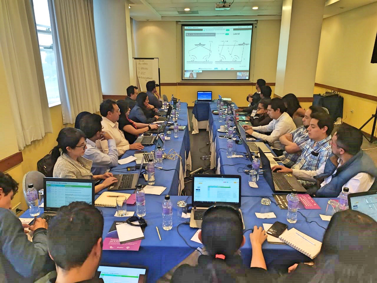
Training on the Use of Synthetic-aperture Radar (SAR) Data for Ecosystem Monitoring
A half-day training session was provided to 25 participants by the Regional Science Associate at NASA, Andréa Nicolau. This introductory workshop on the latest satellite technologies for land cover mapping focused on the practical use of new data sets, such as the Synthetic-aperture Radar (SAR), specifically, the free-access Copernicus’ Sentinel-1. The approach of the training sought to explain radar data management and related issues, such as access to SAR data in the Google Earth Engine platform (GEE), as well as visualization, interpretation, detection of changes, and analysis of time series.
Visits and additional meetings with stakeholders
During their visit to Ecuador, the SERVIR-Amazonia team also took part in meetings with government entities, such as the Ministry of the Environment and Water, the Ministry of Agriculture, the Coordinating Body for the Indigenous Organizations of the Amazon Basin (COICA), and the Consortium of Provincial Autonomous Governments of Ecuador (CONGOPE). In these meetings, potential ideas for services were discussed with technicians from each organization, and progress was made on the coordination for their prompt co-development and implementation.
Authors of this blog post
 Simone Staiger
Coordinator Communications and MEL, SERVIR-Amazonia
 Carlos Gasco
Program Director, SERVIR-Amazonia