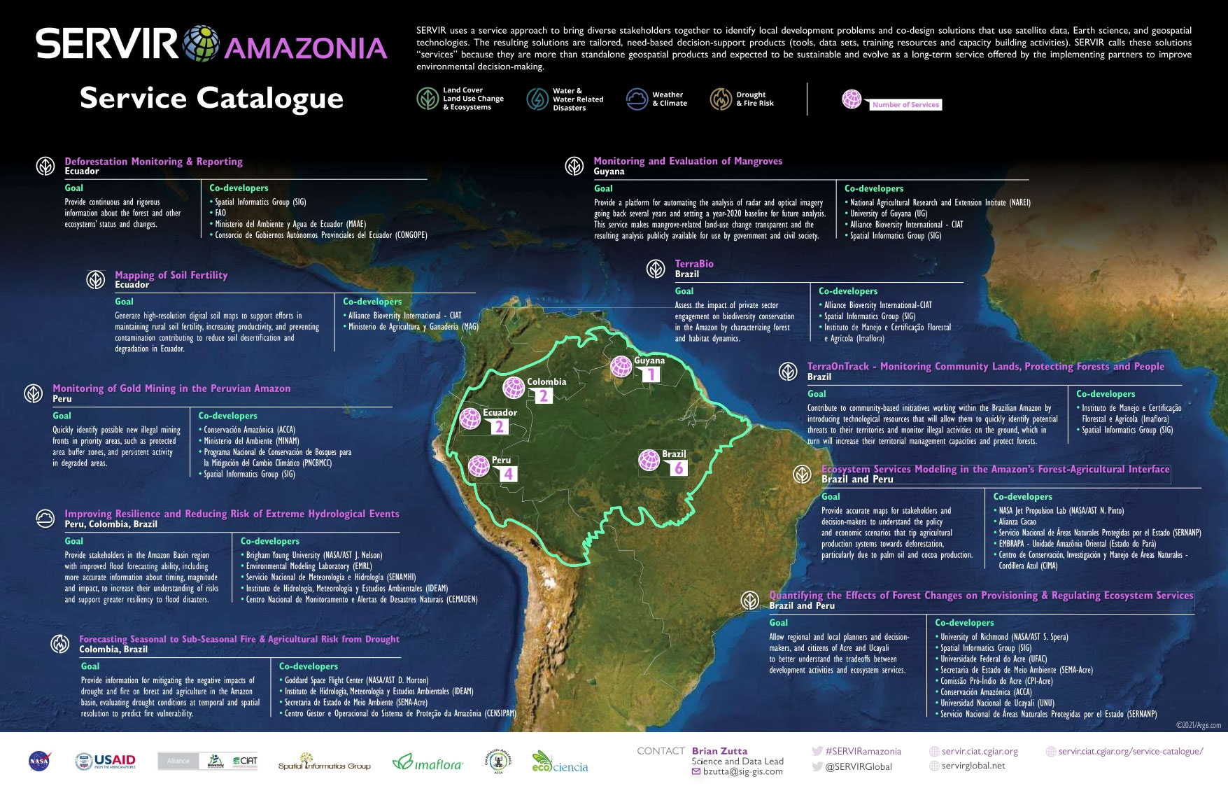
In our most recent newsletter, SERVIR-Amazonia launched a service catalogue with an overview of the geospatial services that we are co-developing with our partners. Over the last two years, we have brought diverse stakeholders from Colombia, Peru, Ecuador, Brazil and Guyana together to identify their development problems and design solutions that use satellite data, Earth science, and geospatial technologies. The resulting services are tailored, needs-based decision-support products (tools, data sets, training resources and capacity building activities) that our partners are about to use to improve environmental decision-making. Discover our summary poster and our services.
Connecting Space to Village: 10 Geospatial Services at a Glance
click on the poster to enlarge
Ecuador
Deforestation Monitoring & Reporting is providing continuous and rigorous information about the forest and other ecosystems’ status and changes.
Read more
Brazil
TerraOnTrack complements community-based initiatives working within the Brazilian Amazon with technologies that will allow to quickly identify potential threats to territories and monitor activities on the ground. Read more
Brazil
TerraBio is assessing the impact of private sector engagement on biodiversity conservation in the Amazon by characterizing forest and habitat dynamics. Read more
Colombia, Brazil
Forecasting Seasonal to Sub-Seasonal Fire & Agricultural Risk from Drought evaluates drought conditions at temporal and spatial resolution to predict fire vulnerability.
Read more
Peru, Colombia, Brazil
Improving Resilience and Reducing Risk of Extreme Hydrological Events provides improved flood forecasting, including more accurate information about timing, magnitude and impact of hydrological events. Read more
Brazil, Peru
Ecosystem Services Modeling in the Amazon’s Forest-Agricultural Interface delivers accurate maps to understand the policy and economic scenarios that tip agricultural production systems towards deforestation particularly due to palm oil and cocoa production. Read more
Brazil, Peru
Quantifying the Effects of Forest Changes on Provisioning & Regulating Ecosystem Services provides maps that highlight areas undergoing changes in microclimatology and land-use to better understand the tradeoffs between development activities and ecosystem services. Read more
Guyana
Monitoring and Evaluation of Mangroves is providing a platform for automating the analysis of radar and optical imagery making mangrove-related land-use change transparent and the resulting analysis publicly available for use by government and civil society. Read more
Ecuador
Mapping of Soil Fertility is generating high-resolution digital soil maps to support efforts in maintaining rural soil fertility, increasing productivity, and preventing contamination contributing to reduce soil desertification and degradation in Ecuador. Read more


