


Looking back at three years of Program implementation, SERVIR-Amazonia saw significant progress in the co-development of services, culminating in the successful delivery of three services in the Land Cover, Land Use Change & Ecosystems service area. Brian Zutta, Science and Data lead of SERVIR-Amazonia reminds us that “this effort spans from initial needs assessments to the design and developments of decision-support systems with our partners, and more recently, to the formal presentation of the products to the wider public. We are transitioning to post-delivery activities engaging with decision-makers and incorporating their feedback.”
See the Service Catalogue and the Service Poster for further information.
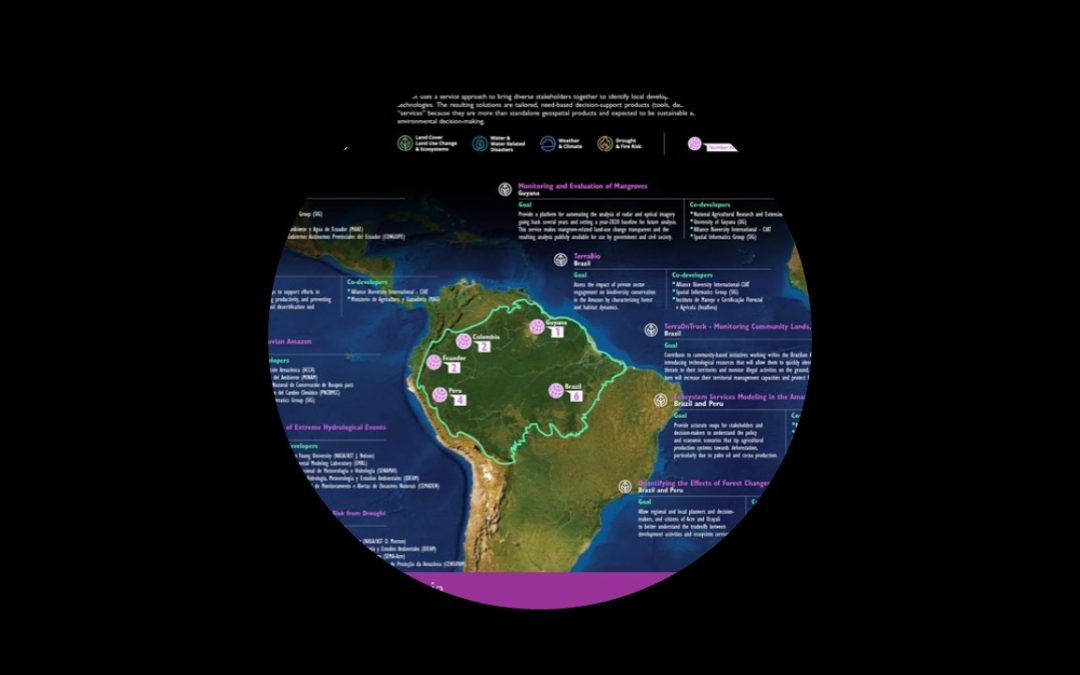
Here are two examples of services that have been launched, their objectives and the co-developing organizations, as well as user testimonies.
Monitoring of gold mining in the Peruvian Amazon
The near real-time information on deforestation and mining activity in the southern Peruvian Amazon, allows authorities to quickly identify possible new illegal mining fronts and to better understand how legal mining impacts the forest. Main product: RAMI
- Ministerio del Medio Ambiente del Perú (MINAM)
- Programa Nacional de Conservación del Bosques y Cambio Climático (PNCBMCC)
- Asociación para la Conservación de la Cuenca Amazónica (ACCA)
- Spatial Informatics Group (SIG)
“RAMI provides new technologies that benefit our Geobosques platform, and its 4000 users. Thanks to this collaboration with SERVIR-Amazonia and ACCA, organizations such as regional authorities, the national government, and Heads of protected areas receive timely and accurate information, which facilitates the planning and prioritization of interventions to stop deforestation due to mining.” Daniel Castillo, Head of Forest Monitoring of the National Program for the Conservation of Forests and the Mitigation of Climate Change, Ministry of Environment of Peru.
TerraOnTrack
The application provides a tool for community-based initiatives in the Brazilian Amazon to improve the monitoring and protection of their forests. Main product: TerraOnTrack
- Instituto de Manejo e Certificação Florestal e Agrícola (Imaflora)
- Spatial Informatics Group (SIG)
“For us producers TerraOnTrack is going to help us a lot, because we did not have that digital part, that possibility of looking from above, from a satellite. With this application we can see it, we can take a map, and generate a notification when we see something that is wrong.”. Emanuel Batista Silva Castro, Leader of the farmer association “Casa Familiar Rural de São Félix”, Talking about the potential of TerraOnTrack during the launch event on September 21.
In addition to those services, the Program contributed to the development of the gold mining monitoring platform COMIMO which was launched by the University of Rosario in Colombia in September 2021. Extensive collaboration was provided with the Ministry of Environment of Ecuador. Glenda Givabel Ortega Sánchez, Secretariat of Natural Heritage, MAATE, Ecuador said that “SERVIR-Amazonia partners strengthened the capacity of the National Forest Monitoring System in mapping land cover and land use changes, a key factor for sustainable forest management and governance.”
The Program also made progress on eight additional services with stakeholders in Peru, Ecuador, Brazil, and Guyana. The four projects supported by the NASA-funded Applied Science Teams concluded their second of three years of operation. Despite the challenges from the current public health situation, they were able to continue to engage stakeholders and conduct virtual workshops, develop, and share geospatial tools and transfer technologies.
“This work would not be possible without the support from NASA on key issues, such as developing the capacity of Program partners, in making valuable connections with other SERVIR Hubs as well as with public and private sector initiatives, such as Alianza Cacao, a USAID funded program in Peru, which provided valuable field data, and NAREI (National Agricultural Research and Extension Institute) from Guyana, which is an active co-developer and provides valuable local expertise”, says Brian Zutta.
Looking Forward
With the first three services officially launched at the end of 2021, SERVIR-Amazonia has entered a new phase in the Program emphasizing the extended use of the services by continuing to integrate the services into the co-developing partner workflows and providing capacity development as well as continued exposure to decision-makers at the partner organizations and their respective stakeholders.
A total of at least three services are scheduled to be delivered in 2022:
- A platform to monitor mangrove ecosystems in Guyana (More info)
- Maps on soil fertility for Ecuador (More info)
- GIS technologies for ecosystem services modeling in the Brazilian Amazon (More info)
All four projects of the Applied Science Teams are scheduled to conclude technical activities at the end of the year. The priority here is to continue collaborations with partners beyond the duration of the AST projects and ensure successful delivery and capacity development. “We look forward to continuing our active collaboration with NASA and their multiple opportunities to improve our capacities, for example in the area of Land Cover and Land Use Change”, concludes Brian Zutta. The Program also participates actively in the Land Cover Change Intercomparison project, which is assessing multiple machine-learning algorithms and methodologies across SERVIR regions. The results of this project will strengthen the capacity of the hub in the development of land cover related services. Global partnerships/collaborations with key GEO (Group on Earth Observation) activities and programs will leverage SERVIR-Amazonia’s profile as a regional expert and service provider in Land Cover mapping activities and will be strategic to broaden their donor agency network. These include GFOI (Global Forest Observations Initiative) and the upcoming activities associated to disseminate the OpenMRV platform led by the World Bank, and the new initiative GEO-TREES, which aims to build a Forest Biomass Reference System (FBRS) to support global space-based forest biomass mapping.